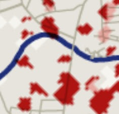
The Economist published this map of structural damage in Gaza. Light pink is before the ceasefire, and darker red is since the ceasefire.
Even at a glance, one can see that Israel's targeting is much different now.
If you compare this with a satellite map of Gaza, you see that most of the damage since the ceasefire has been outside of crowded residential areas. Most seem to be aimed at industrial districts and what appears to be farmland. (I imagine tank damage might count as structural damage as well.)
The Economist maps seems to be slightly off when comparing their streets with the satellite, but this section near a curve in Wadi Gaza where there is heavy damage is illustrative.
Here's the satellite image of the area:
The apparent target north of the wadi is the Al Zahraa Chalet hotel and a structure next to it.
What appears to be happening is that as Israel gathers more and more intelligence, especially from captured terrorists, it is discovering many more specific targets that Hamas uses. As its intel improves, the need for heavy bombing to collapse tunnels decreases, since now the IDF can target specific tunnel entrances - very likely under a hotel - or weapons caches.
|
 Buy the EoZ book, PROTOCOLS: Exposing Modern Antisemitism today at Amazon! Buy the EoZ book, PROTOCOLS: Exposing Modern Antisemitism today at Amazon!
Or order from your favorite bookseller, using ISBN 9798985708424.
Read all about it here!
|

|

 Elder of Ziyon


![[Elder of Ziyon] Facebook may add "Insha'Allah" button for events](https://blogger.googleusercontent.com/img/b/R29vZ2xl/AVvXsEi9KIDYyRBYSDMD-x2PZwXZNYKl0eHCeNWbuEWt6IvsNL6IFhtZTpF2SvNRlui4o-nPTjPMcmSOxJ1nPo0pPGPzI5r7GHO_ZfKV9WUcNnkMeMslnkgWq0GeILJg-5vXLLCLckj6SUmdJqmc/s72-c/arabic_facebook_logo_by_ali_normal-d37tr0q.jpg)


0 comments:
Post a Comment